My UPD8
You need to login before you download the free activities. You can register here.
- The Centre for Science Education
- The Association for Science Education
- Partners
- Part of ASE online
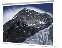
Shrinking Everest?
Type: Activity
Learning Strategy: Group discussion
Topic: Rocks & weathering
The summit of Everest is the highest place on Earth. But unpublished data from China suggests its height may have dropped recently. That's odd! In the past, India's steady northwards migration has crumpled the crust and kept the mountain growing. Chinese scientists – in collaboration with a women's expedition to the summit – will check the mountain's height in March using radar and GPS.
STOP PRESS: It was reported in New Scientist of 15 October 2005 that 'The elevation of Mount Everest's summit is 8844.43 metres, with a precision of 10.21 m' (Chen Bangzhu, director-general of the Chinese State Bureau of Surveying and Mapping) - so the world's highest mountain is 3.7 m lower than previously thought.
Published: 3rd February 2005
Reviews & Comments: 10
Learning objectives
Students will appreciate the slow pace of geological change and that it is sometimes difficult to obtain data that is both precise and reliable. They will use information about factors that affect the mountain's height to estimate the value the Chinese expedition will come up with.
Try the activity
- Activity sheet
Downloaded: 5459 times - everest_teachers_notes.doc
Downloaded: 2522 times
You will need Acrobat Reader installed to open the activity sheets.
Curriculum link
Rocks and weathering [QCA 8g] – describe the physical and chemical processes by which rocks are weathered and transported and relate these to features of the environment.Plate tectonics [KS4] – describe what happens when plates collide.
Considering evidence [KS3] – use, observations, measurements and other data to draw conclusions.
Running the activity
Suggested time: 20 minutes
Possible starter:
Set the scene by displaying page 1 on OHT or by projector. This sets the scene and presents the task. Pupils have to estimate the height this year's survey of Everest will come up with. Ask for pupils ideas about why the mountain's official height has changed over the years.
Main activity:
Ask students what the different measuring techniques involve and clarify any misconceptions. The basis of GPS is "triangulation" from satellites. To "triangulate," a GPS receiver measures distance using the travel time of radio signals. Line-of-site surveys use theodolites. These are telescopes whose angle of tilt can be adjusted very precisely. The angle needed to get the top of the mountain in view, and the distance from the mountain, can be used to calculate its height. Electronic measuring devices make it easy to get accurate distance readings these days. In the past, finding the distance was a difficult and time-consuming process.
Pupils should be divided into small groups and each will need a copy of page 2. Ask students to read the information cards and pick out those that could explain Everest's changing height. They should sort these into explanations for increasing height and explanations for decreasing height. Then they should use the magnitude of each change to estimate the expected annual change and the new value the Chinese survey will obtain. Students will then need 10 minutes to write individual paragraphs explaining the group's prediction.
Possible plenary:
If time allows, let students share their predictions with the rest of the class.
Background Notes:
The heights of mountains are measured from sea level. Sea levels used to be determined by averaging the readings from tidal gauges. But these are affected by tides and local gravitational differences. The sea levels on the two sides of India are different. GPS systems base height measurements on an ellipsoid surrounding the entire earth. They take local variations in the Earth's magnetic field, which stop the oceans lying completely flat, into account.
The data supplied suggests that the Everest's height should still be rising due to tectonic activity. Its crustal roots should also be rising from the mantle as it loses weight due to erosion and the shortening of the glaciers. The increased erosion should not affect the height directly because it takes place below the summit. Changes in the measurement systems could account for differences in the height but GPS measurements do not drift by more than a few centimetres.
One effect of global warming is to speed up the conversion of soft snow to solid ice. This could make the mountain look slightly shorter. Although global warming may not be having too much affect on the mountains height, its consequences could be serious. These are explored further in a previous UPD8: Glacial Meltdown.
Web links
News links
- BBC
- A brief summary to set the scene.
- Times
- A chronology of height measurements.
- Guardian
- A good summary mentioning erosion, plates shifting, isotactic forces and glaciers.
- GPS
- An excellent step-wise illustrated explanation of how GPS works.
Reviews & Comments
Write your online review to share your feedback and classroom tips with other teachers. How well does it work, how engaging is it, how did you use it, and how could it be improved?
BIOLOGY
Sep 12th, 2009

Very Good and an interesting topic
Reviewer: indu indu
Shrinking Everest? review
Jun 23rd, 2009

excellent resource, makes rocks fun!
Reviewer: aimee monaghan
Shrinking Everest? review
Mar 30th, 2009
top set year 7 really enjoyed this activity. worked really well summing up the rock cycle.
Reviewer: Katherine Lyell
Shrinking Everest? review
Jan 15th, 2009
Used this activity as part of revision of the rock cycle unit. Really worked well - though the lower ability students found some of the ideas difficult to understand- you may want to introduce the idea of plates moving before using it.
Reviewer: Stu Wright
Shrinking Everest
May 20th, 2008

Set for a low ability year 8 cover lesson having been taught the topic content. Students made lovely posters for me but needed teacher input to really understand the task. Would complete the task with low ability in teacher led activity another time.
Reviewer: Tracey Holmes
Shrinking Everest
Feb 1st, 2006
I used this activity with a middle ability GCSE Y10 class towards the end of the
Earth module. We had just finished looking at the formation of Mountain ranges and I thought this would fit nicely as an activity to look at the factors which contribute to the erosion of mountains as well and the impact of global warming (tying in another part from the AQA Double Award SOW).
I split pupils into groups, introduced the activity and then asked them to feed back their answer to Q3 (Estimated height of Everest) with reasons - via the 'Show me boards'. There was a lot of discussion - about how new techniques improve the accuracy of measurement and reporting; the impact of global warming, whether the factors contributing to increase should outweigh those contributing to decrease' etc.
The students worked well in their groups - staying focussed on the task and realising the need to justify their responses. They were challenged and also wanted to know what the correct answer was. In a topic that can often be 'dull' this was a good way of applying Assessment for learning strategies.
I then asked the students to consider which factors where affected by global warming and we went on to look at that in more detail.
(I was observed for this lesson and received positive feedback - so Thanks!!!!)
Reviewer: sarah longshaw
Shrinking Everest Review
Jul 8th, 2005
I used this activity with a middle set Year 9 group. We have been focusing on coursework skills after the SAT's and this activity allowed us to focus on the importance of justifying predictions or conclusions using all the evidence available. We started with a large picture of Mt Everest on the IWB with a few starter questions about the mountain eg. What is this mountain called? Where is this mountain? (Which most students didn't know!) How high is the mountain? and What is it famous for? This got the students attention. We talked a little about the height of Mt Everest and the two different methods of measuring (line of sight and GPS) - I actually had a new 'Teach First' participant in school who did a very good 5 minute presentation on the two methods of measurement. Students made a prediction of the height using the information on slide 1. Most thought that it would increase, although a few dissenters had their voices heard and talked about errors in measuring and how this could affect the appearance of the pattern of the results. We then handed out pre - cut information cards and asked students to sort the cards. Then, using all the information from the cards and what they'd learned of the measuring techniques, students were asked to prepare a poster presentation stating their prediction, with relevent justiifications.
I grouped the students by ability and the lower attainers had a few prompt questions in order to help structure their presentation. Pupils then presented, we started with the lower ability groups presenting first and gradually worked our way up and the ideas and justifications became more complex. We graded the presentations using criteria we had shared with the students (Quality of poster, accurate and relevant use of evidence, clarity of voice, participation of whole group and the X factor mark).
The next lesson we revisited a piece of coursework and pupils looked at their predictions and conclusions and added relevant justifications.
Overall - a very neat way of engaging students and helping them develop useful skills.
Thank you UPD8!
Jonathon Lisseman, Quintin Kynaston School, St John's Wood, London.
Reviewer: Jonathon Lisseman
UPD8 REVIEW OF SHRINKING EVEREST
Jun 11th, 2005
GREAT ACTIVITY
I used this activity really well with 2 different GCSE Year 10 classes. One class was a middle ability class and the other was a low ability class. We spent about 20 minutes on the activity as a lesson starter. At Comberton VC we follow the OCR Double Award Staged Assessed GCSE Science course. This activity fits nicely into the Y10 Chemistry Module CD3 "Rocks and Metals". I have now included this activity into our Y10 Scheme of work within the lesson, which covers the formation of Sedimentary Rocks and the idea of Plate Tectonics providing an explanation for the recycling of Rocks. It also links in well as a reminder of the Year 8 work covered in the QCA topic on Rocks and Weathering. This activity also gets students to consider the controversial nature of Science and how conflicting evidence can present different answers.
I started this activity by showing the first slide to the class and drew their attention to the survey data table showing the different calculated heights of Everest. Students considered the data and then made a prediction about what the Chinese scientists would calculate using modern Radar and GPS techniques. Most students thought that the height of Everest would have increased in line with the general upward trend in the data. I then got them into pairs in order to consider the evidence cards from a photocopied second sheet. The information cards on this sheet describe a number of processes that could explain whether the height of Everest would increase or decrease.
The students worked well in pairs on this part of the activity. I got them to cut out the evidence cards, read them and discuss whether they supported an increase or a decrease in the height of Everest. Interestingly, most of the groups wanted to make a third pile of evidence cards that had evidence which did not support either an increase or decrease in height. Groups labelled this the "evidence not clear" pile. This part of the activity certainly promoted lots of thinking and discussion between groups. The evidence cards were then stuck onto coloured paper and each group quickly explained their ideas and prediction to the rest of the class. Most significantly, nearly all the groups changed their original prediction in the light of the evidence and thought that the measured height found by the Chinese scientists would be lower. The students then wrote a paragraph into their books explaining their ideas behind their prediction.
I thought that this activity presents a really nice way into a potentially difficult topic.
Richard Waller, Comberton Village College, Cambridge
Reviewer: Richard Waller
Shrinking Everest
May 20th, 2005
I used this with Y8 pupils having done some work on erosion etc. They had some general knowledge about tectonic plates but lack of formal teaching on this didn't hamper the idea.
We were trying to make an educated guess for the height using the data - so we wrote it down as a sum with guestimates for each effect.
Toward the end I did the same idea on the board and made my estimate.
I hope I will remember that I have these in my drawer when the actual figure is published - they would make a great display.
Reviewer: Ann Corbin
SATS revision
May 9th, 2005
I used this activity as a starter for an interview. Went down well with kids - rocks is a bit of a dry topic, however this made a dull topic more real and fun. The students were low ability year 9 and they got on well. coming up with ideas of why Everest may be shrinking. AN entertaining and interesting look into rocks.
Reviewer: Emma Griffiths
![]()
200 lessons and assessments from as little as £4.95
Related Activities
Earth Science / Rocks & weathering
Difficult & Dull / Rocks
QCA / 8G Rocks & weathering
Ideas about Science / Interpreting evidence
- Death of an angel
- Christmas trifle
- Pomegranate ovary model
- Boys, girls, and chimps
- The short side of the family
- Fast car
- Secrets from the ice
- Pluto: a planet no more
- Shampoo claims - truth or lies?
- Gold
- Goya: huge, hunted, and extinct
- Rats
- Grow your own body
- Ban cola?
- Attack of the giant viruses
- Solar roadways
- Life on Enceladus?
Learning Strategy / Group discussion
- Boys, girls, and chimps
- Fireworks
- Is life a dream?
- Disgust
- Mobiles for kids?
- New faces
- Stromboli erupts
- UK kids top asthma league
- Say No to poor health
- Nuclear power: the great debate
- Bionic arm moved by brain waves
- New Womb?
- Celeb science
- Homeopathy: is it Science?
- Cyclone
- Bulb danger
- Asthma
- Goal-line technology